Travel Planner
“Pictured Rocks: The East End”
Episode #1913 Travel planner
Starting at the Grand Marais Ranger Station we discover incredible trails through the Grand Sable Dunes to the Grand Sable Falls and up the Grand Sable Light and then onto shipwreck discovery.
Free Guide
Share your thoughts on this episode and get information and guides to the areas featured by filling out the comment form
Comment Form
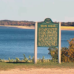
Grand Marais, Michigan
Pictured Rocks National Lakeshore
Location: 1505 Sand Point Road - Munising, MI 49862
Directions: State highway M-77 leads to Grand Marais on the east side. Alger County Road H-58 runs parallel and through the park, providing access to spur roads that lead to scenic overlooks, trailheads, campgrounds, beaches, etc. Many roads are closed in winter due to snow.
Hours: Open year-round, 24 hours a day
Sandstone cliffs, beaches, waterfalls, sand dunes, inland lakes, deep forest, and wild shoreline beckon you to visit Pictured Rocks National Lakeshore. The power of Lake Superior shapes the park's coastal features and affects every ecosystem, creating a unique landscape to explore. Hiking, camping, sightseeing, and four-season outdoor opportunities abound.
- Pictured Rocks National Lakeshore [National Parks Service]
Grand Marais, Michigan
Location: Alger County, Michigan
The historic village of Grand Marais is located on the south shore of Lake Superior at the eastern gateway to Pictured Rocks National Lakeshore. Come enjoy the waterfalls and lighthouses of this 50-mile stretch of pristine Lake Superior shoreline. Hike and bike our trails, relax on our beaches, and step back in time at our museums. Whether you enjoy water sports, winter sports, or just a relaxing getaway, we have something for everyone!
- Grand Marais [Pure Michigan]
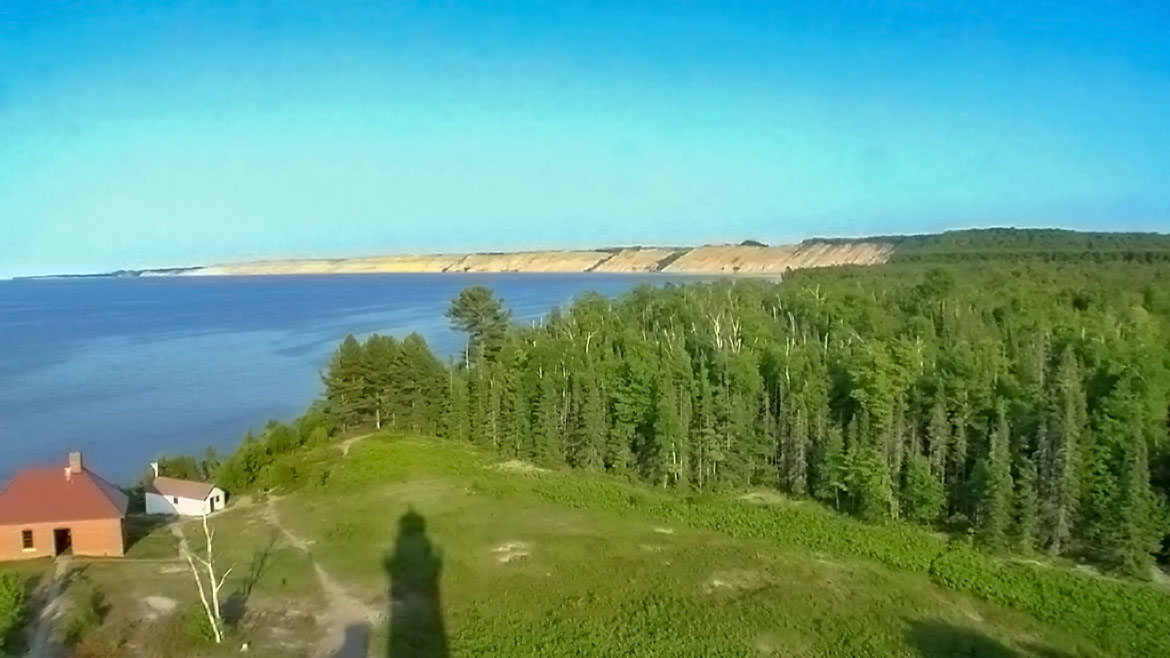
Eastern District Ranger Station
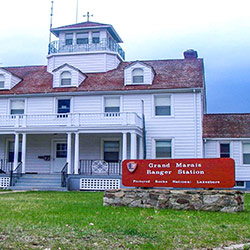
Location: E22030 Coast Guard Point Road -Grand Marais, Michigan
The U.S. Coast Guard opened this station in 1938, replacing a structure built in 1899 by the U.S. Life Saving Service. The Coast Guard deactivated the station in 1981, and transferred the property to the National Park Service. The three story wood frame building overlooks Lake Superior, and currently serves as a ranger station for Pictured Rocks National Lakeshore. A keepers quarters is nearby as well as the Harbor of Refuge building.
- Pictured Rocks National Lakeshore - Maritime Sites [National Parks Service]
Sable Falls
Location: One Mile West of Grand Marais, MI on Alger County Road H-58
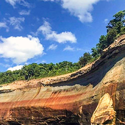
Sable Falls tumbles 75 feet over several cliffs of Munising and Jacobsville sandstone formations on its way to Lake Superior. The first viewing platform to the falls is down a staircase with some 170 steps. The .5 mile trail to Lake Superior beach is a nice walk. Pets are not permitted on this trail.
The beach at the end of the Sable Falls Trail is part rock and part sand, with views of the Grand Sable Dunes towering above. The trail from the parking lot is only about 1/3 mile long but there are 168 steps to the bottom of the falls and a few more steps along the remaining path to the beach. Please remember that collecting beach stones is not permitted within the national lakeshore. Picnic tables and restroom are available near the parking lot. Pets allowed.
- Pictured Rocks National Lakeshore - Waterfalls [National Parks Service]
- Pictured Rocks National Lakeshore - Sable Falls Beach [National Parks Service]
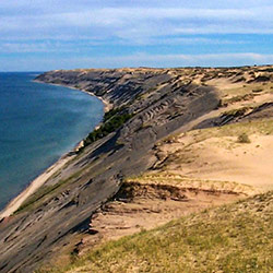
Grand Sable Dunes
Location: Pictured Rocks National Park
The best place to view the Grand Sable Dunes is from the trail that begins at the west end of the Sable Falls parking area. This trail leads through an old field, then crosses a bridge over Sable Creek. It then ventures into the forest and dunes transition area for approximately 1/4 mile. Wayside exhibits are located along the trail. Another access point for the dunes is from the North Country Trail 1/4 mile east of the Log Slide. Please stay on the trail in both of these areas as the dunes vegetation is fragile.
Five square miles of Grand Sable Dunes are perched atop the 300-foot high Grand Sable Banks. A portion of the Grand Sable Dunes is set aside as a Research Natural Area. These enormous dunes left by glacial action are located at the eastern end of the park.
- Pictured Rocks National Lakeshore - Grand Sable Dunes [National Parks Service]
AuSable Point Light Station
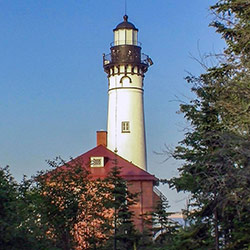
Location: Au Sable Point, 12 miles west (drive) of Grand Marais to the Hurricane River Campground then 1.5 miles (walk) east. Tours are available during summer.
In 1872, Congress appropriated $40,000 to build at lighthouse at Au Sable Point. The light station began operation on August 19, 1874. At 86 feet high, the light tower is the tallest lighthouse on this stretch of the southern Lake Superior shore. The original fixed white light could be seen 17 miles out on the lake.
- Pictured Rocks National Lakeshore - AuSable Light Station [National Parks Service]
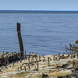
Hurricane River Campground
Location: Alger County, Road H-58, Pictured Rocks National Lakeshore, Grand Marais, MI 49839
Where the Hurricane River flows into Lake Superior. Twenty-one campsites. A level 1.5 mile walk on the North Country Trail leads past shipwreck remnants to the historic Au Sable Light Station. Picnic table, fire grate and tent pad provided. All camping is by reservation only. Reservations for campsites can be made on recreation.gov. All campsites are $20 per night.
- Pictured Rocks National Lakeshore - Drive-In Camping [National Park Service]
- Hurricane River Campground [Recreation.gov]